


By Alex Sosnowski, AccuWeather senior meteorologist
Even though accumulating snow is likely to avoid much of Interstate 95 from Philadelphia on south, the impending storm and nor’easter will deliver heavy, travel-snarling snow farther to the north and west, and the New York City area may be a snow versus rain battleground, AccuWeather meteorologists continue to warn. For some areas of the Northeast, this will still be the heaviest snowfall in two years.
Those with travel plans on the roads, rails and skies this weekend should be prepared for weather-related disruptions as a fast-moving storm is intent on producing a period of moderate to heavy snow from the central Appalachians to much of New England.
Accumulating snow is in store for approximately 60 million residents in the Northeast this weekend. Among those who will be affected by the storm are hundreds of thousands of college students returning to campuses following the extended holiday break.
“In portions of New England, upstate New York and in parts of Pennsylvania, the snow will fall at the rate of an inch per hour or more, and that could be difficult for road crews to keep up with,” AccuWeather Chief Meteorologist and Senior Vice President, Weather Content and Forecast Operations Jonathan Porter said. This could cause some motorists who venture out during the height of the storm from Saturday afternoon to early Sunday to become stranded on the highway.
Snow will quickly spread over the central Appalachians and northern tier of the mid-Atlantic on Saturday and then onward to much of New England during Saturday night. Warm Atlantic Ocean waters, in the 40s F, will play a huge role in the form of precipitation for the mid-Atlantic coast and on Cape Cod, Massachusetts, by preventing snow or limiting the amount of snow.
At this time, AccuWeather meteorologists believe that little to no snow will fall along a line that roughly follows Interstate 95 from Washington, D.C., to Baltimore, Philadelphia and central New Jersey.
Fluctuations in the intensity of the precipitation may be enough to allow a coating to an inch of slushy, wet snow along this zone. Just to the north and west of I-95 in this swath, several inches of snow and a wintry mix will occur, along with a reality check that the calendar has recently flipped to a new year and new month.
Conditions will change near New York City as the storm will begin to strengthen significantly around this massive metro area, and the precipitation rate is likely to become much heavier.
“This looks to be a sharp gradation in snow accumulation around the New York City metro area with little or no snow in eastern Brooklyn and Queens with 1 to 3 inches in Manhattan, where the best chance of inches is on the upper end of Manhattan and the Bronx,” AccuWeather Meteorologist and 10-10 Wins Radio Personality Dean DeVore said.
The snow may fall on the front end of the storm or in multiple periods where rain and snow switch back and forth. Areas to the southeast of New York City would experience mostly rain. However, only a few miles north and northwest of the New York Metro area, colder air is likely to hold its ground and lead to a much heavier snowfall that will ramp up to 6-12 inches and locally higher amounts in portions of southeastern New York, western Connecticut and northern New Jersey.
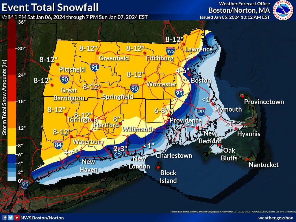
“This will be a major snowstorm from northeastern Pennsylvania to central New England, including the Boston area, where 4-8 inches of is likely to accumulate around the harbor and heavier amounts near and west of I-95.
Among the cities likely to pick up 6-10 inches of snow from the storm spanning Saturday to Sunday include Scranton, Pennsylvania; Albany, New York; Hartford, Connecticut; Rutland, Vermont; and Manchester, New Hampshire.
A broad zone where 3-6 inches of snow will fall extends from along the borders of Virginia and West Virginia through much of central and southeastern Pennsylvania, central New York, central Maine and just inland of the southern coast of New England.
Because of the quick movement of the storm, an excessive amount of snow that could rival some of the biggest snowstorms to hit the area is highly unlikely to occur. However, the AccuWeather Local StormMax™ snowfall for this is 20 inches, which is a formidable amount of snow for any winter storm.
Still, enough snow is likely to fall to bring the biggest single storm in two years to many locations such as State College, Pennsylvania; Caldwell, New Jersey; Danbury, Connecticut; and Boston. The last storm to bring more than 4 inches to Boston/Logan International Airport was on Feb. 25, 2022, when 8.5 inches of snow fell.
The same quick movement and last-minute strengthening of the storm will prevent long-duration winds. Any coastal flooding will tend to be minor and brief along the eastern coast of New England on Sunday. Brisk winds in the wake of the storm may lead to some minor blowing and drifting snow from late Sunday to Monday, where rain or ice did not mix in.
For those who were not able to travel ahead of the storm into Friday night, conditions will improve from west to east across the region on Sunday afternoon and Sunday night, provided highways are not clogged with stalled cars and accidents that occurred during the height of the storm from Saturday afternoon to Sunday morning.


